
The inhabitants of Western Ukraine have a traditionally ingrained stereotype about the good old Austrian Empire, which managed to put the local region in order and set up a state administration apparatus that, like clockwork, performed its duties properly.
The documentary heritage that has remained since those times largely confirms such views. In particular, it is still surprising today how carefully the Austrians kept land records, accurately calculating the sizes of even the smallest land plots of the poorest local peasants. One is even more surprised when one finds these plots marked on handwritten cadastral maps from the mid-19th century.
In this article, we will talk about land ownership documents that belonged to residents of the Ukrainian SSR in the second half of the 19th and early 20th centuries…
This type of document includes extracts on land ownership. Today they are stored in the Central State Historical Archive of Ukraine in Lviv, where they are collected in fund No. 186. Such extracts were compiled in 1879, when the government of the Austrian Empire conducted an audit of land ownership in the country. The new cadastres were based on the principle of calculating net income from units of area of certain agricultural land. Each type of land was divided into eight classes according to its quality. This classification was based on soil surveys and the calculation of income that could be obtained from their use. When surveying the plots, climatic conditions, physicochemical properties of the soil, position above sea level, communication routes, and the state of land reclamation were taken into account.
In Galicia, the document forms were drawn up in Russian and Polish. The document was called "Extract from the report of the assessment and evaluation (land estate list) for the purpose of filing objections" (Wyciąg z obliczenia pomiru i oszacowania (arkusz posiadłości gruntowej) potrzebny do podawania reklamacyj). These documents were drawn up for all landowners of the time in Galicia and have been perfectly preserved to this day. The materials are grouped according to the geographical principle, that is, the extracts are filed in separate files according to the geographical points to which specific land plots belonged. In view of this, the title page contains the name of the crown land (Galicia), the county as a geographical unit and a taxation unit, as well as the name of the community to which the plot belonged.
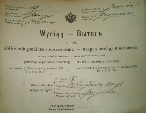
The title page indicated the name and surname of the owner of the plot, his place of residence and the number of the house in which he lived. Therefore, extracts from land ownership are also documents that will help in studying the family lineage and genealogy of the family. If the plot was jointly owned, then a separate column on the title page indicated the number of co-owners.
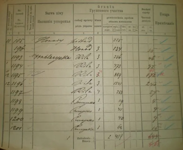
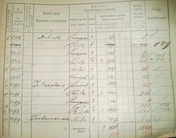
Extracts on land ownership were directly related to cadastral maps, which were carefully compiled for each village after the abolition of serfdom in Galicia in 1848. Therefore, the first column of the table on the state of land ownership indicated the number of the map sheet with the image of the plot. The next column is the number of the plot (parcel), which was individually assigned to each allotment. This number can be found on cadastral maps or other documents related to land ownership.
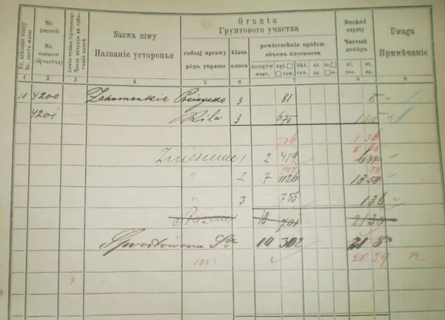
The most important information is contained in the columns «Name of the field» (Nazwa niwy) and «Grunty» (Grunty). The first contains the name of the plot, which was tied to the topographic features of the area (for example: “behind the brickyard”, “humus”, “to Khmelyk”), or the type of use of the plot (“garden”). The next column contains information about the purpose of the plot, its class and area. By purpose, it could be arable land, vegetable garden, hayfield, pasture, forest, plot under a house, etc. The class of the land determined its quality, and this, accordingly, affected the possible income. The area of the plots was given in morgues and sazhens. Today, one morgue is equal to 0.58 hectares, and sazhen is 4.55 sq. m. Finally, in the table, a separate column determined the net income that could be obtained from the plot.
For example, let's analyze the extract on the land ownership of Vasyl Havrylechko, who in 1879 owned land plots in the village of Hniynytsia, Yavoriv district. If we present his land ownership in a table, it will look like this:
|
Sheet number on the map |
Parcel number |
Site name |
Type of use |
Class |
Area (morgues, fathoms) |
Income (gold, kreuzers) |
|
11 |
105 |
Vegetable gardens |
under the house |
|
0,225 |
|
|
|
196 |
|
backyard |
3 |
0,134 |
0,3 |
|
|
1193 |
(?) |
arable |
3 |
0,236 |
0,46 |
|
|
1194 |
|
arable |
3 |
0,473 |
0,92 |
|
11,12 |
1195 |
|
arable |
4 |
0,889 |
0,93 |
|
12 |
1196 |
|
arable |
3 |
0,1241 |
2,4 |
|
|
1197 |
|
arable |
4 |
0,253 |
0,27 |
|
|
1198 |
|
grazing |
1 |
0,19 |
0,4 |
|
|
1199 |
|
grazing |
1 |
0,41 |
0,9 |
|
|
1200 |
|
grazing |
1 |
0,4 |
0,9 |
|
|
1201 |
|
grazing |
1 |
0,68 |
0,15 |
|
5 |
3208 |
See you later. |
grazing |
4 |
0,55 |
0,1 |
|
|
3209 (crossed out) |
|
arable |
6 |
0.399 (exc.) |
0.22 (ex.) |
|
|
3211 |
|
grazing |
4 |
0,106 |
0,3 |
|
5; 6 |
3213 |
|
arable |
5 6 |
2,974 |
0,85; 1,66 |
|
6 |
3215 |
|
arable |
6 |
0,709 |
0,38 |
|
|
3216 |
|
haymaking |
3 |
0,141 |
0,40 |
|
6; 10 |
4195 |
Behind the brickyard |
haymaking |
3 |
0,222 |
0,62 |
|
10 |
4196 |
|
arable |
4 |
1,641 |
2,38 |
|
|
4197 |
|
grazing |
3 |
0,6 |
0,4 |
|
10; 11 |
4198 |
|
arable |
3; 4 |
1,1272 |
2,78; 1,53 |
|
11 |
4199 |
Rubbery |
arable |
3 |
0,1347 |
2,60 |
|
11 |
4200 |
|
|
|
|
|
|
|
4201 |
Zagumanske |
grazing |
3 |
0,81 |
0,6 |
|
|
|
|
arable |
3 |
0,675 |
1,30 |
| Together: |
10 morgues 302 fathoms |
20,29 |
||||
Thus, by today's standards, Vasyl owned land with a total area of about 5.91 hectares. At that time, this was quite enough to support his family with dignity.
If you are interested in what your ancestors owned over a century ago, you can try to find the documents described above in the archives yourself. You can also contact our specialists who will help you find land ownership documents, as well as read them correctly, translate them, and analyze the state of your ancestors' property.
Read also: